Adi Talwar
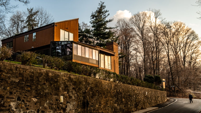
A property inside the Riverdale Special Natural Area District.If a tree falls in the forest and no one is around to hear it, does it make a sound?
If the forest in question comprises 90 acres along east bank of the Harlem River, a felled tree never goes unnoticed. Here, a “Special Natural Area District” (SNAD) zoning overlay—NA-2, specifically—covers the Bronx neighborhoods of Riverdale, Fieldston, and Spuyten Duyvil. The Department of City Planning asserts tight control over development in this SNAD (as it does in two other SNADs in Staten Island and one in Queens) in order to protect what it calls the area’s “unique natural characteristics.” The effect of the protective zoning is starkly visible in NA-2, which appears by satellite as a green glitch in the uniform density of the Bronx. At the ground level, rock outcroppings and mature trees shield sprawling single-family houses and winding narrow roads. It feels like another world—or at least, not like New York City.
For SNAD residents like Sura Jeselsohn, that’s just how it should be. “Concrete is the enemy of the human spirit,” Jeselsohn said in an interview with City Limits. That’s why she moved to Riverdale nearly 50 years ago, and why she’s spent decades as a local watchdog, reporting suspected violations of the SNAD rules in an effort to preserve the quiet idyll that she calls home.
But this year, citing unnecessarily cumbersome bureaucracy and outdated environmental standards, DCP proposed an amendment to the zoning overlay that governs development in the Staten Island and Bronx SNADs. Reflecting nearly four years of negotiations between elected officials, planning professionals, institutional leaders, and homeowners, the proposal’s stated mission was to standardize and streamline the process by which small homeowners make changes to their properties, while bringing the protections of the special zoning into the 21st century.
But residents like Jeselsohn were unconvinced. She, along with a coalition of environmentalists and Riverdale residents—homeowners and tenants of both the SNAD and adjacent areas—fought the changes in the Bronx. Their Staten Island counterparts were no more enthused. In May, DCP dropped the Staten Island districts from its proposal, and on October 10 unceremoniously withdrew the Bronx-only amendment from consideration as well. “Though changes were made in response to community concerns during public review, DCP does not see a way to resolve remaining issues and so has withdrawn the application from ULURP. The current SNAD regulations remain in effect,” DCP’s website announced.
But the city’s dry bulletin belied the protracted battle fought over this seemingly arcane policy adjustment. In fact, its demise was a study in classic conflicts between ownership and the urban.
Special since the seventies
“Special Purpose Districts” have been a feature of New York zoning laws since 1969, when the city began affording extra planning oversight in areas deemed uniquely significant. The parameters of these districts reflect the politics and priorities of their times, from the Special Coastal Risk Districts covering parts of Queens and Staten Island since 2017, to various Special Mixed Use Districts that seek to manage the gentrification of post-industrial neighborhoods throughout the city. Three out of the four Special Natural Area Districts were established between 1974 and 1977; also within that interval, the city established Special Districts to preserve the view from Brooklyn Heights, the “nautical heritage” and “village quality” of City Island, and the “historic character” of Little Italy. It was, evidently, a preservationist time.
Rather than red-brick tenements or Victorian mansions that preserve the city’s heritage, the Special Natural Area Districts target the “natural features” that preserve its ecological stability, as well as the districts’ “unique aesthetic value.” Hillsides are maintained both for the sake of picturesque views and in order to prevent erosion and reduce run-off; trees are protected as habitat for humans and non-humans alike.
The rules that formalize these protections are complex. The chapter of the zoning resolution that establishes SNADs details nearly two dozen kinds of natural feature eligible for oversight, while setting out an elaborate calculus to determine what qualifies as a “steep slope,” and how tall a tree must be in order to count towards the conservation requirements. Much of the land within the Staten Island and Bronx SNADs is zoned residential, and thus under normal circumstances could be developed as-of-right. But the special zoning overlay dictates that anyone seeking to change the exteriors of existing buildings or build new ones must submit an application for review by the local Community Board and approval by the City Planning Commission (CPC).
This, according to a DCP spokesperson, was the crux of the problem with the SNAD regulations as they stood in 2015, when the city began formulating its proposed update. A small homeowner seeking to make a minor renovation to their property—installing a deck, say—could spend more than a year and up to $25,000 seeking approval. Furthermore, DCP argued that in 40 years, environmental science had moved beyond the regulatory framework set out in the SNAD rules. (For instance, LIDAR, a surveying method which gathers data about surface composition using laser beams, had allowed a more sophisticated understanding of the areas’ ecological dynamics beyond tree-counting, DCP said.) The zoning update would make the process less burdensome, for homeowners and the city alike, while differentiating between projects based on their environmental impact.
Seeking a ‘balance’
The proposal would have bundled the SNADs in Staten Island and the Bronx along with two other Special Purpose Districts in Staten Island into a single district, subjecting properties under one acre to a standardized permitting process, while preserving CPC review for larger parcels. But updates to the environmental protections fomented controversy. The proposal traded the mission of SNADs laid out in the ‘70s—”to protect, maintain, and enhance” natural features in a given district—for a more 2010s enterprise—”to balance development and ecological goals.” The new zoning treated properties abutting public parks differently than others in the district, and set the baseline allowance for hard surface area at 50 percent of a given lot. This standard became a flashpoint in the struggle between the city and the resistant homeowners who ultimately doomed the proposal.
In a comment on the city’s Draft Environmental Impact Statement, the Bronx Council for Environmental Quality (BCEQ) described the increase in impervious surfaces as a “critical and fatal flaw” of the proposed zoning update. Increasing the surface coverage to 50 percent from 30 percent, the current district average, could increase stormwater runoff, BCEQ argued, unbalancing fragile aquatic ecosystems. Indeed, according to Jodie Colón, the self-described “research desk” of the Riverdale resident opposition movement, the proposal threatened an environmental bulwark for the whole city by allowing small property-owners in the SNAD to remove trees and make landscaping changes as-of-right. Colón, herself an environmental educator, pointed to the role NA-2 plays in guarding the city’s watershed and moderating the infamous urban heat island effect.
In Staten Island, resistance took the same object, but an opposite tack. In Staten Island, such a limit on impervious surface coverage could well help mediate the effects of flooding like that which damaged several neighborhoods during Superstorm Sandy. But in the non-SNAD Special Districts like South Richmond, the 50 percent limit posed an entirely new regulatory hurdle for developers and homeowners. In May, as the zoning amendment moved through public review, it met resounding dissent from Staten Island community boards and elected officials who said it unfairly prevented owners from developing their property. In its official recommendation to vote down the proposal, Community Board 3—in the South Richmond Special District, which had not previously fallen under SNAD rules—condemned the proposed impervious surface limit as “an intrusive land grab” and a “usurpation of property rights.” In a statement to the Staten Island Advance, Board Chairman Frank Morano compared the limit to outright theft.
Fears of density
From the perspective of SNAD preservationists like Sura Jeselsohn, an increase in surface coverage points not only to ecological imbalance, but to densification. According to Jeselsohn, “everything is under attack” in Riverdale—and the enemy is development. Though the Bronx SNAD would have remained zoned for mainly single-family residential development, Jeselsohn and many others in the coalition sensed that loosening the special district’s grip on the development process might mean losing ground to the densification pressures at work in the rest of the city. Jeselsohn objected to the notion that Riverdale, as part of New York City, might be required to contribute to resolving its housing crisis. “The SNAD is useful as an extra layer of protection,” Jeselsohn said.
Though she is only one homeowner, Jeselsohn’s status as president of Along the Hudson Homeowner’s Association and as a central figure in the opposition to DCP’s proposal subjects her comments—in which she discusses the dangers and dirtiness of high-density housing populated by those she calls “people from the lower classes*”—to more scrutiny. “We used to have gangs running the projects. Who would want to live in high density?” Jeselsohn mused. “What’s the guarantee that all of these things will not come home to us, here, where everybody wants to lead a quiet, safe life?”
For Colón and her co-organizer Stephanie Coggins, the threat is not density and its denizens but the city’s attempt to impose a new reality on the residents of Riverdale from the top down. Coggins and Colón drew parallels between their successful defeat of DCP’s proposal to community resistance to rezoning occurring in neighborhoods across the city; “We hope that other communities are inspired,” Colón said. Certainly, the ULURP process has many problems, not least of which may be the merely advisory capacity of Community Boards. (It was only by applying pressure to City Councilmember Andy Cohen that Colón et al. were able to prevent the update from going through.)
But it’s an open question whether residents of East Harlem or Inwood—bracing for impact from a wave of displacement and demographic change in the wake of the neighborhood’s rezoning, even as the affordable housing crisis escalates—would find Riverdale’s triumph inspiring. After all, the boundaries of the SNAD also demarcate some of the racial lines created by de facto segregation in New York City.The southern end of the SNAD, abutting settled neighborhoods in the Bronx rather than the vast expanse of Van Cortlandt Park, reveals the dynamic most clearly. In 2015, Census Track 029302, representing part of Spuyten Duyvil, was roughly 75 percent white and Asian and 23 percent Black and Latino. The track to the east, just outside the SNAD, represents the Marble Hill neighborhood: 92 percent Black and Latino, 7 percent white and Asian, and much more densely settled.
The path ahead
Still, environmental considerations cannot be set aside. Green pockets like the SNADs are inarguably useful to the maintenance of the city’s ecological balance. Those who seek to maintain the greenery do not necessarily have ulterior motives. But it is nevertheless the case that, from a restrictive covenant in the 1910s to the Riverdale Community Planning Association in the 1950s, well-to-do property owners in this bucolic enclave have long harnessed rhetorics of community control and environmental conservation to keep Riverdale just as they like it. The contrast between that vision and the pressures felt throughout the rest of the city is becoming more and more stark.
In a statement to City Limits, a DCP spokesperson said that the city plans to revisit alterations to the Special District zoning in Staten Island, seeing “opportunities for further discussions with the community.” But for the foreseeable future, the trees of Riverdale will stay quiet and undisturbed.
*Correction: The original version of this article erroneously reported this quote as “lower-class people.”




4 thoughts on “How Environmental Concerns, Property Activism and Density Fears Halted a Bid to Change NYC Zoning Rules”
This sounds like a make-work project for the NYCDCP more than anything else. In the combined Bronx and SI NAs 96.7% of the 2769 residential properties are 1-family homes. The NYCDCP has nothing better to do than drag this tiny number of homeowners through their bureaucracy? The NAs will never be upzoned or changed in any meaningful way as they are remote areas of the city with very limited infrastructure. The South Richmond District (71% 1-family homes) is more populated but has the same limited infrastructure and also will never be upzoned.
The idea was to create more as-of-right rules to remove bureaucracy, but oh well.
The racism argument is unfair. Over crowded neighborhoods with bad air should not be used to urge more develpment in areas that are still nice to live in. Perhaps it could be used as an argument for returning some places to nature where poor people live. Lack of housing can be addressed by rent control, not more building.
Interesting. How would the “return to nature” work?