Share This Article
Department of City Planning
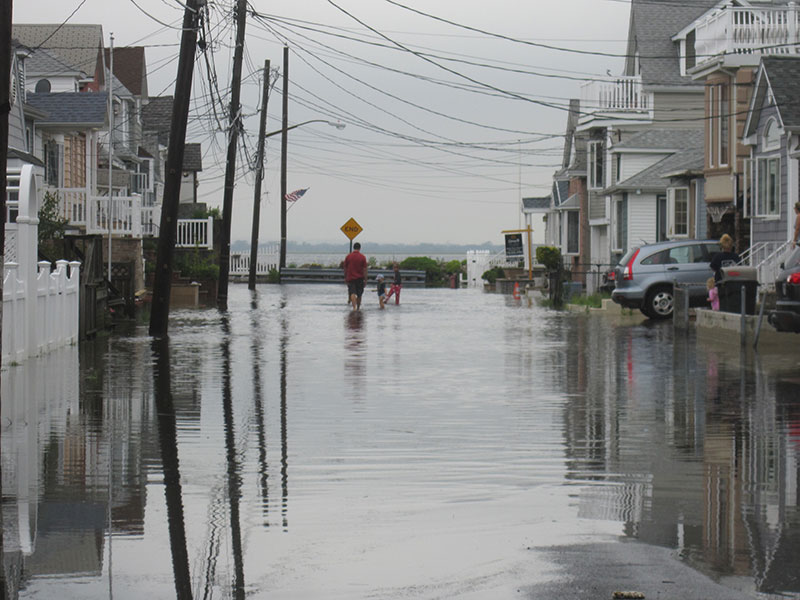
Flooding in Broad Channel, one of dozens of neighborhoods that faces serious threats from sea-level rise and coastal storms.When New Yorkers cast their ballots in November’s presidential race, they will also have a chance to vote on a $3 billion bond act that, advocates say, gives the metropolitan region a chance to be ready for the higher seas and stronger storms that climate change will almost certainly send its way.
Right now, New York City and its neighbors are far from prepared for that threat. That’s why a coalition of more than 50 groups calling itself Rise to Resilience on Friday released a detailed strategy blueprint of comprehensive, dramatic action to brace for New York and New Jersey’s wetter future.
“How do we address the six feet of sea-level rise we expect by the end of the century?” is the simple if daunting question the report tries to answer, according to Kate Boicourt of the Waterfront Alliance, which convened the coalition. “There really has been no group fighting for the 1 million-plus and rising who are in the floodplain now in New York and New Jersey.”
The ballot measure, the Environmental Bond Act of 2020, which passed the state legislature in March, would create up to $3 billion in funding—a large chunk of it devoted to coastal resiliency and flood-risk reduction. While polls earlier in the year showed broad support for the measure, the new fiscal politics created by COVID-19 make passage less of a sure thing.
The bond measure is just one piece, however, of the platform that Rise to Resilience has crafted over two years of consensus-building. Other elements of the plan include federal infrastructure funding, flood insurance, local land-use planning, buyout financing and more. In addition to the Waterfront Alliance, the coalition includes groups like the Coney Island Beautification Project, LES Ready!, New Jersey Future, Rebuild by Design, Riverkeeper, The Center For NYC Neighborhoods and WE ACT for Environmental Justice.
A million at risk
New York has certainly made progress since Hurricane Sandy’s arrival in October 2012 demonstrated the scope of the region’s vulnerability to coastal storms. In the city, miles of boardwalk and dunes have been strengthened in the Rockaways and along Staten Island’s shoreline. A billion dollars has gone to shoring up city infrastructure, and still more has been spent on hardening schools and hospitals, according to city officials. More complex projects, like the East Coast Resiliency Project, are under way.
That work has run parallel to ambitious efforts at the city and state level to reduce New York’s contribution to climate pollution. Last year, the City Council passed and Mayor de Blasio signed a suite of legislation to reduce emissions in the city—especially from buildings, the leading source of CO2 from the five boroughs—and the state legislature and governor came together on a law that mandates a dramatic reduction in carbon emissions by the year 2050.
However, a paddle along the city’s extensive waterfront would detect massive vulnerabilities, especially in areas where small, private homes—many owned by people of modest means—cluster near the shoreline.
“Since Hurricane Sandy struck, strong commitments have been made to greenhouse gas reduction and a state sea level rise standard—but we remain unprepared for the sea level rise we face in any scenario,” Rise to Resilience said in the report it released Friday.
For Boicourt, the disparity between the dramatic action on greenhouse-gas reduction and the slower, more selective work on resiliency reflects the different contours of the underlying problems.
“I think its partly that the movement and the ideas of what to do have evolved a little more over time with mitigation and greenhouse-gas reduction than for flood-risk reduction,” she says. “I think the challenge with climate adaptation is there are fewer point sources for that. You can’t just change the electrical grid.” In fact, the very scale of risk on the waterfront—a million or more people, in different neighborhoods, separate localities and across two states—is a challenge to crafting comprehensive policy.
Waiting for the feds
For many years, the U.S. Army Corps of Engineers’ study of the harbor and its tributaries dominated thinking about how to better protect New York’s shoreline. The Corps was just coming around to finalizing a plan when the Trump administration froze funding earlier this year.
“The Trump administration’s decision to indefinitely postpone regional planning for climate adaptation places New York City and our neighbors in danger,” says Jainey Bavishi, Director of the Mayor’s Office of Resiliency, in a statement to City Limits. “We are continuing to work with our Congressional delegation to explore all options for reinstating the NY-NJ Harbor and Tributaries Study as quickly as possible. This effort is a critical component of addressing regional flood risk and must not be abandoned.”
Before it went on hiatus, the Army Corps seemed to be leaning toward recommending the building of a massive sea barrier in the outer harbor—an undertaking that would take many billions of dollars and perhaps a couple decades to complete, and that could damage the underwater ecosystem. Critics say the Army Corps focused too much on defending against storm surge as opposed to the broader threats of sea-level rise and riverine flooding. And they believe the Corps was never given the resources to do deep engagement with the people who would most affected by the plan.

Still, as Boicourt notes, the Corps’ study represented “one of our few chances for federal funding for flood risk reduction.” As a result, Rise to Resilience is calling for the resumption of a more thoughtful and responsive Corps study. “A lot of the people who have been organizing against the barrier and even some that were for it are with us on this,” she says. “They want to see a conversation that focuses on what we want at the grassroots level.” And there has been movement in Washington toward restoring and protecting funding for the study.
Meanwhile, the National Flood Insurance Program (NFIP) remains $20 billion in debt and mired in questions over the accuracy of the maps it uses and the fairness—to taxpayers as well as moderate-income property owners—of its premium system. Rise to Resilience sees a robustly funded NFIP, using modern mapping and a premium system that reflects actual risks but includes affordability mechanisms, as key to managing risk on the shoreline in the New York region and beyond.
Two states, one crisis
Scarred by Sandy, both New York and New Jersey have each created an apparatus to address the threat of sea-level rise and coastal storms. But there’s not really a comprehensive, unified approach to what is by its nature a regional, multifaceted threat.
Rise to Resilience recommends that New York State create a chief resilience officer and link or even merge initiatives like the Coastal Zone Management Program and the Climate Smart Communities program. Albany also needs to craft more tools for cities and towns that are trying to mitigate their risks, revise construction codes to reflect climate considerations and create financing mechanisms to help localities pay for the necessary infrastructure work.
New Jersey ought to create a committee of stakeholders to make sure resiliency considerations shape local land-use policies, and revise 13 sets of regulations and codes to align with climate-preparedness goals, the report recommends.
And the two states should jointly empower a Regional Climate Resilience Council to unify policymaking across the harbor and the border, the coalition argues.
Meanwhile, in both states, right-to-know laws are also under scrutiny. In New York and New Jersey a property seller can avoid having to disclose flooding risk to a potential buyer merely by paying $500. More robust disclosure requirements are essential, the coalition contends. “Consumers should have a right to know their risks,” the report reads. “Knowing the level of one’s risk helps change patterns of behavior related to flood insurance, increasing uptake of up to 15 percent or more.”
There are, however, two sides to that coin. If homeowners are forced to acknowledge the risks associated with living on the shoreline, it could make their homes virtually unsellable.
“The reality is its going to be difficult for many people to sell their properties in the future, no matter what,” Boicourt says. “We have to have the ability to have resources for people who are facing financial difficulties as a result of being in a really risky area.” That includes long-term, voluntary buyout programs, which do not exist in the region at present.
A delicate planning process
Individual homeowners already in the water’s path will need to make difficult choices, and so will governments who, through land-use policy, decide how many people will live in one place or another.
“We need a plan that is updated over time about where we can afford more density and where we can’t,” Boicourt says. “These are very delicate conversations that the city has to commit to.” Not every area with flood risk faces the same kind of threat – some will see daily flooding, while others will be vulnerable to severe storms every few decades. For those that do face serious and sustained risks, merely elevating properties might not be enough, and people might have to relocate, with government help.
Any change in the relationship to the water is a painful prospect for communities whose identities is linked to the sea. However, it’s not just shoreline areas that need to think about what climate change will mean for land use. Inland areas at good elevation might need to accept higher housing density as encroaching water shrinks the city’s usable footprint. “I’m talking about looking at the whole city,” Boicourt explains. Just as an example, she asks, “Should we be upzoning Park Slope more than we are?”
In New York City, there’s a new push to pass Intro 1620, a City Council measure that requires “a comprehensive five borough plan to protect the entire shoreline of New York city” to be produced by January 1, 2021 and updated every decade, which was introduced last year by Queens Councilmember Costa Constantinides. The measure has 41 Council co-sponsors—a veto-proof majority—but there has been no action on it since a hearing last October, at which the de Blasio administration said it opposed the bill because it could conflict with the Army Corps study and because it didn’t allow for community engagement.
In his sweeping March report on protecting the city from climate change, Council Speaker Corey Johnson appeared to signal that a revised version of Intro 1620—with more time for conversations with neighborhoods—was on the table.
“The development of such a plan would be a multi-year process because of the number of communities facing climate risk, the importance of the study being grounded in the NPCC’s climate change projections, the technical feasibility of implementation, and the critical role of community engagement,” Johnson wrote. “Consideration could be given to adopting a phased approach wherein the most vulnerable neighborhoods are engaged first, with successive deadlines to work with additional communities on localized plans to address vulnerabilities.”
The release of the Rise to Resilience plan on a day that New York City faces a possible tropical storm was a reminder that coastal vulnerabilities are here now, and will only grow. But Bavishi, the mayor’s resiliency czar, notes that climate change presents other threats, too. “Adaptation planning cannot begin and end at the shoreline,” she says, “which is why our strategy holistically considers all of the climate threats New York City faces – including extreme heat and inland flooding caused by heavy downpours.”
1 Comment
red-bike
Thanks for this coverage. There’s lots of news about what happened yesterday, what’s going on today, and what’s scheduled for tomorrow. This story is about what’s likely ten, fifty, one hundred years from now, though today’s tropical storm adds urgency.
I plan to vote for Environmental Bond Act that will be on the November 2020 ballot. But full coverage of this question should acknowledge: municipal bonds are paid for through taxes, mostly real estate taxes. When property owners’ rent-paying tenants (both residential and commercial) don’t pay rent, it’s difficult or impossible for those property owners to pay real estate tax.
More about flood-related right-to-know laws: flood forecasts aren’t secrets only known to property sellers unless the risk is unique to a specific property. Flood forecasts aren’t perfect. They’re squishy. But they’re public. Prospective buyers shoulder the burden of seeking out this data.
And thanks for repeating the message that higher-density development in neighborhoods with low flood risk is one of the best responses to this challenge.