NYC ORR
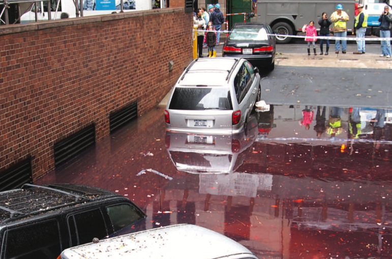
Flooding in Lower Manhattan after Hurricane Sandy.
With sea levels around New York City expected to rise as much as six feet over the next nine decades, federal planners are considering what would have been unthinkable just a few years ago: a $120 billion network of defensive measures including seven miles of tidal gates and 26 miles of shoreline structures like floodwalls.
And that’s just the most extensive—and expensive—of five alternatives examined in an interim report released this week by the Army Corps of Engineers.
In its long-awaited “New York-New Jersey Harbor and Tributaries Coastal Storm Risk Management Interim Report,” the Corps does not recommend a course of action. That recommendation will come sometime before the agency’s initial environmental impact statement for its New York resiliency project is released for public review in March of 2020.
The Corps says this week’s interim study exists merely to ” identify factors that warrant further investigation.” To that end, eight public meetings are planned so the agency can hear public opinion on their analysis. Details on the first four sessions are as follows:
Tuesday, March 12th, 2019, 5-7 p.m. at the Westchester County Center, 198 Central Avenue, White Plains, N.Y.
Wednesday, April 3rd, 5-7 p.m. at the Hudson Valley Community Center, 110 Grand Avenue, Poughkeepsie, N.Y.
Thursday, April 11th, 5-7 p.m. at the Meadowlands Environment Center’s first-floor auditorium, 2 DeKorte Park Plaza, Lyndhurst, N.J.
Wednesday, April 17th, 5-7 p.m. at the Hostos Community College, D Building/Savoy Manor Building, 120 East 149th St, 2nd Floor, Bronx, N.Y.
The Corps says four additional public meetings will be announced soon. Each session will include a 30-minute period for reviewing explanatory displays, a 30-minute staff presentation and a 60-minute public comment period.
In related news this week, the Corps, state and city announced they would fund a network of levees, berms, and seawalls stretching from Fort Wadsworth to Great Kills on Staten Island’s East Shore and designed to withstand a 300-year storm. The project, due to be complete in 2022, will cost the feds $400 million with the state and city chipping it $151 million and $65 million, respectively. Mayor Bloomberg had earmarked city money for the project.
Climate risks, project costs
The rationale for the Corps’ study is, in a word, the superstorm.
“The impacts from Hurricane Sandy highlighted the national need for a comprehensive and collaborative evaluation to reduce risk to vulnerable populations within the North Atlantic region,” the Corps writes. “Historic sea level change has exacerbated flooding over the past century, and potential sea level change in the future will only increase the magnitude, frequency, and extent of the problem.”
The Corps is not the only entity pursuing resiliency projects—New York City has a program of its own to improve coastal resiliency and there are similar efforts underway elsewhere in New York state and in New Jersey—at least 160, by the Corps’ count. And improving resiliency doesn’t just involve construction projects: Public education, property buyouts, wetlands restoration, and “retreat” are also in the policy toolbox, the report notes.
When it formalizes its recommendation over the next year, however, the Corps appears likely to recommend building something—or rather, building a system of things, over many years and at a significant cost.
At this stage, the agency has established five possible approaches. (A chart of these is below.)
One plan would use a “combination levee, berm and surge gate/barrier system” from Sandy Hook, N.J., to Breezy Point in Queens, as well as a surge barrier (an example of one type of such barrier can be seen here) just west of the Throgs Neck Bridge, effectively sealing off the city from “storm surge and wave attack” coming from the Atlantic or the Long Island Sound. There would also be barriers in the water and on shore at Pelham Bay. This approach would basically create a harbor-wide barrier system, and is by far the most expensive.
A second option would be to have three “regional” surge barriers—at the southern end of the Arthur Kill between New Jersey and Staten Island, at the Verrazano Narrows between Staten Island and Brooklyn and up near the Throgs Neck—forming a tighter ring around the harbor. The Pelham Bay work would also happen here, as would a system of surge gates and floodwalls around Jamaica Bay.
Option Three involves mid-sized surge gates at Arthur Kill and Kill Van Kull on Staten Island and smaller gates and other measures at the mouth of Jamaica Bay, Gerritsen Creek, Sheepshead Bay, and Coney Island Creek as well as the Bronx River and Westchester Creek, Pelham Bay, Flushing Creek, Newtown Creek and the Gowanus Canal.
There’s another approach that would install a large number of small surge gates and other measures on Jamaica Bay and the other New York City tributaries, and add a small gate at the Hackensack River in New Jersey.
Yet another approach would eschew surge gates altogether and instead build a lot of berms and floodwalls on the perimeter of many area waterways.
The agency also examines, pretty briefly, the possibility of taking no action.
Get the best of City Limits news in your inbox.
Select any of our free weekly newsletters and stay informed on the latest policy-focused, independent news.
Major questions remain
According to the Corps, the different approaches come with different price-tags, ranging from $15 billion for the no-gates plan to $120 billion for the harbor-wide barriers. They also each provide different levels of protection: The harbor-wide barriers would reduce flooding risk by 92 percent, for instance. Attaching a dollar value to those different levels of protection, the Corps’ analysis indicates that the plan for regional sea gates—at Arthur Kills, the Narrows and Throgs Neck—offers the best buy: reducing 89 percent of flooding risk at a construction cost of $47 billion, penciling out to a $124 billion net benefit.
Those numbers, however, are but a rough guide. The Corps notes that its assessment of how effective each plan would be is based on a particular model of how water is going to flow in the storms of the future, with key assumptions around how much the sea will rise and how long into the future the analysis should run; change that model, and the answer about which plan is most cost-effective might also change.
At least two of the plans could protect inner areas of the region at the expense of producing more flooding elsewhere. The Corps says more modeling is necessary to better understand those tradeoffs. A crucial question is what the trigger would be for closing the storm-surge barriers. “Is it the 50 percent flood, the 20 percent flood, 10 percent flood,” the report asks, “or some other event?
There are also questions about how how each plan would affect navigation on the water and what impact the different strategies would have on the ecosystem: the “benthic communities” on the ocean floor, the water column in which fish dwell, wetlands along the coasts and the birds that live on the surface or the shore.
The report is here, and there are supplemental items for review here.
U.S. Army Corps of Engineers Harbor Resiliency Options
| Plan | Elements | Cost Estimate | Amount of flood risk reduction | Estimated net benefit | Map |
| Harbor Wide Storm-Surge Barriers | – a combination levee, berm and surge gate/barrier system connecting to Sandy Hook, New Jersey, across the transect to Breezy Point of Rockaway peninsula – a surge barrier enclosure along the East River just west of the Throgs Neck – a small embayment next to Pelham Bay Park in the Bronx along western Long Island Sound |
$118.8 billion | 92 percent | $57 billion | Alternative 2 |
| Regional Storm-Surge Barriers | – surge gate measures at the southern mouth of the Arthur Kill, the Verrazano Narrows, and at the Throgs Neck – a combination of shoreline-based measures (like floodwalls and levees) along with multiple surge gate structures in the southern Brooklyn to the mouth of Jamaica Bay and then to Rockaway Peninsula – a small embayment next to Pelham Bay Park in the Bronx along western Long Island Sound |
$47.1 billion | 89 percent | $124 billion | Alternative 3a |
| Mid-Sized Storm Surge Barriers | – a surge gate system at the southern mouth of the Arthur Kill – a surge gate system the eastern mouth of the Kill Van Kull between Bayonne, NJ and Staten Island, NY – a combination of shoreline-based measures (like floodwalls and levees) and multiple surge gate structures in the southern Brooklyn to the mouth of Jamaica Bay and then to Rockaway Peninsula – a small embayment next to Pelham Bay Park in the Bronx along western Long Island Sound – surge gate structures and adjacent on various tributaries located within the city in predominantly low lying areas with adjacent shoreline-based measures at the southern Bronx shoreline (including the Bronx River and Westchester creek), Flushing Creek (Queens), Newtown Creek (boarder of Brooklyn and Queens) and the Gowanus Canal (Brooklyn). – shoreline-based measures on the New Jersey shoreline along the Hudson River, the lower West Side of Manhattan, East Harlem in Manhattan along the East and Harlem Rivers, and Long Island City and 5) Astoria in Queens. – shoreline-based features at various low-lying communities (two in Yonkers, one in Tarrytown, one in Ossining, and two in Stony Point) along the Hudson River. |
$43 billion | 83 percent | 117.8 billion | Alternative 3b |
| Small Storm-Surge Barriers | – a combination of shoreline-based measures and multiple surge gate structures in the southern Brooklyn to the mouth of Jamaica Bay and then to Rockaway Peninsula – a surge gate system at the southern mouth of the Hackensack River, NJ. – a small embayment next to Pelham Bay Park in the Bronx along western Long Island Sound – surge gate structures and adjacent on various tributaries located within the city in predominantly low lying areas with adjacent shoreline-based measures at the southern Bronx shoreline (including the Bronx River and Westchester creek), Flushing Creek (Queens), Newtown Creek (boarder of Brooklyn and Queens) and the Gowanus Canal (Brooklyn). – shoreline-based measures on the New Jersey shoreline along the Hudson River, the lower West Side of Manhattan, East Harlem in Manhattan along the East and Harlem Rivers, and Long Island City and 5) Astoria in Queens. – shoreline-based features at various low-lying communities (two in Yonkers, one in Tarrytown, one in Ossining, and two in Stony Point) along the Hudson River. |
$32 billion | 78 percent | $116.6 billion | Alternative 4 |
| Perimeter Defenses | – excludes any large in-water structures – shoreline defenses in the lower Hudson River estuary, the Hackensack Meadowlands, and along the East and Harlem Rivers. – shoreline-based features at various low-lying communities (two in Yonkers, one in Tarrytown, one in Ossining, and two in Stony Point) along the Hudson River. |
$14.8 billion | 25 percent | $33.8 billion | Alternative 5 |


One thought on “Corps of Engineers Eyes Multibillion-Dollar NYC Defenses vs. Climate Change”
Pingback: Does New York City Need a Sea Wall? Your Chance to Weigh In Has Arrived « Sara D. Roosevelt Park Coalition