
Bob Hennelly
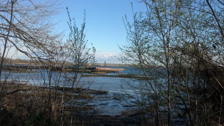
Newark Bay, seen from Staten Island. Once an active fishery, then an industrial dumping ground, the Bay has the potential to be an asset rather than a threat to the low-income communities around it.
By early morning light, the view of Newark Bay from the northern shore of Staten Island is one of awesome natural beauty. The wide open expanse of water and coastal marsh grasses sway under an infinite blue sky in which maritime birds do an air ballet. The City of Newark, for which the Bay is named, glistens in the distance several miles away like OZ. In the foreground, a tug towing an oil barge slides by on chilly spring water while a phalanx of giant cargo container cranes stands at attention.
This portion of Staten Island’s waterfront is a patch of blighted public access off Richmond Terrace. Old barrels are mired in a muck that holds decades of flotsam and jetsam as well as the ruins of abandoned docks and decrepit barges. A dark metal sign marked Public Health Advisory warns: “Pregnant women, women of childbearing age, and children under 15 should not eat fish or eels caught in these waters.”
Thanks to the migration of much of the region’s heavy manufacturing overseas, and tens of billions of dollars invested in sewage treatment by both states, overall water quality has improved in the bi-state estuary of which Newark Bay is part. The increase in the presence of dissolved oxygen in the water has helped marine life rebound. Even the bald eagle is reported to have made a comeback here.
But both state’s have fish advisories and consumption bans in place for good reason. For well over 100 years before the passage of the 1972 Federal Clean Water Act, industries dumped chemicals and solvents into the waterways and wetlands because that was just how business was done. Today, managing the run-off from scores of legacy Superfund sites on the banks of the bay remains a major challenge. Companies still legally discharge millions of pounds of chemicals into Newark Bay and its major tributaries under state and federal permits.
Newark Bay is at the center of the controversial proposed deal between the state of New Jersey and the Exxon Corporation to settle for a mere $225 million claims for nearly $9 billion in natural resource damage claims stemming from the oil giant’s operation of their Bayonne and the Bayway sites going back almost a century. The deal, which is currently the subject of a public comment period that ends in early June, also includes 16 unrelated Exxon sites around New Jersey as well as several hundred gas stations.
Critics say the deal lets Exxon off too cheap. The Christie administration counters that it’s the largest natural resource damage (NRD) payout in state history and, if approved, will bring an end to lengthy and costly litigation. And Governor Chris Christie’s administration has also noted the settlement is what Exxon must pay in addition to clean-up costs for the sites, which Exxon says already exceed $260 million.
But there’s disagreement about exactly what constitutes an adequate “clean-up” of the area. Beyond that, environmental advocates and community members on both sides of Newark Bay are concerned that no matter what the total amount of the NRD settlement ultimately is, only a fraction of it will actually be used to address the environment. Last year the Christie administration diverted $140 million from a $190 million settlement in an NRD case involving the massive contamination of the Passaic River to balance the state budget, leaving just $50 million to actually deal with environmental issues. In Christie’s proposed budget for next year he has plans to do the same thing with the proposed Exxon deal.
For Newark Bay, the questions people have asked about the Exxon deal—about the overall size of the settlement, about how it will be used—are crucial to a body of water that links low-income communities in two states, and connects an area’s maritime past to its post-industrial present. Some see in the settlement a chance for a future where proximity to the bay is seen as an asset, not a threat.
A fishery, then a dump
The Bay is a bi-state tidal estuary that’s five and a half miles long and between six-tenths to over one mile wide in places. Both New Jersey’s Hackensack and Passaic Rivers flow into it. The Bay is linked to the Upper New York Bay by the Kill Van Kull to the south east and connected to the Raritan Bay via the Arthur Kill to the southwest. On its western shore Newark Bay includes the cities of Newark and Elizabeth and on the east side Jersey City and Bayonne. To the south its roughly rectangular shape is framed by the northern shore of Staten Island.
It was once part of one of the richest fisheries in the world. Into the 19th century, the region prided itself on an oyster harvest that employed several hundred families and provided affordable protein for generations. Before there were hot-dog stands there were oyster carts. These days Newark Bay is a surreal mix of sanctuary for well over a hundred different bird species and a maritime super-highway over which ships carry hundreds of billions of dollars worth of cargo ranging from from imported beer to petrochemicals.
From colonial times to the 20th century both New Jersey and New York saw wetlands and coastal marshlands as a threat to the public health and the source of mosquito-borne illness. As a result it was government policy to see filling wetlands as both an economic development tool to create tax-yielding, profit-producing real estate and a way to protect the public health.
As a consequence, according to the The State of the Estuary 2012, published by the New York-New Jersey Harbor Estuary Program, the region “lost the vast majority of wetlands that were present when the Dutch began colonizing the area. Roughly 80 square miles, or 85 percent, of the coastal wetlands that existed in the 1800s have been filled or drained.”
In both New Jersey and New York, the value placed on wetlands was so low that both states saw them as places to dump massive quantities of residential and commercial solid waste. Both the landfills in the Jersey Meadowlands and New York City’s Fresh Kills landfill on Staten Island were sited on what had once been salt-water marshes, fresh-water wetlands or tidal wetlands. Generations of garbage dumping turned them into environmental blights visible from space. Illegal dumping was widespread and remains a problem for both states.
“When people filled in these wetlands they lost storm-water storage but they also covered it with impervious surfaces which sends pollution directly into the harbor,” says Christopher Len, staff attorney with the NY NJ Baykeeper.
With the 1972 passage of the Clean Water Act, the tide began to turn for wetlands and marshes as scientists linked their preservation with improving water quality and natural habitat while providing cost-effective flood control. “Each acre of wetlands can hold one million gallons of water,” says Jeff Tittel, of New Jersey’s Sierra Club.
Life by the bay
Today the Newark Bay and its major tributaries host not just the bulk of the region’s maritime cargo-handling facilities, but also refineries, chemical plants, sewage treatment plants and some of the most toxic Superfund sites in the nation. In and around these facilities and hot spots close to one million people make their home in communities along the Newark Bay bi-state waterfront.
Despite advisories, people from both states continue to do subsistence fishing. “They’re fishing because they are poor or there is a language barrier, or they don’t believe the sign,” says Michael Edelstein, an environmental psychologist and a professor at Ramapo College.
U.S. Census data indicates these communities are made up of people of color with a substantial percentage of new immigrants: mostly Spanish-speaking arrivals getting their first toehold here in the United States. The Bay is far from the only health hazard nearby: These communities host heavy industry and are are also at the heart of the region’s cargo-handling choke-point. As a consequence they bear the brunt of both point-source and ambient air pollution that is tracked by both state and Federal regulators. Public health data indicates that just three of the counties in New Jersey on the Newark Bay complex account for a third of the hospitalizations for asthma in the state. According to the EPA data, the neighborhoods around Newark Bay—in both states—have historically displayed higher incidence of cancers.
In Linden, N.J. on the Arthur Kill, part of the Newark Bay complex, Phillips 66 operates the massive Bayway refinery that was established by Standard Oil’s John D. Rockefeller in 1907. Last year Environment New Jersey reported that based on 2012 data from the U.S. Environmental Protection Agency the plant discharged over two million pounds of two dozen different chemicals like xylene and toluene into a creek which runs into the Arthur Kill. “This is not a crime. It is permitted pollution,” says Doug O’Malley with Environment New Jersey. “It is egregious but it is the letter of the law.”
Experts caution about drawing any direct causal link between public health data and particular facilities or toxic hot spots, but patterns of health care disparities and outcomes along socio-economic lines have been well-documented.
Edelstein, one of the nation’s leading experts on communities that have to grapple with the ambiguities and uncertainties environmental contamination brings, says it simply: “If you’re a rich person living in a contaminated home you just move. You have options.” But those with lower incomes have less flexibility. “It is not just that you are exposed to a particular environmental hazard. It is that your choice of where to live is constrained as is your ability to control what’s allowed to happen around you.”
A community steps up
Ana Baptista, an assistant professor of environmental policy and sustainability at the New School, grew up on the Newark side of the Newark Bay in that city’s Ironbound section. For several years she led the Ironbound Community Corporation’s fight to get the state and federal governments to address the notorious Diamond Alkali site on the Passaic River where Agent Orange was manufactured.
The site received Superfund designation in 1984. In addition to some of the highest levels of dioxin ever discovered, investigators found the lower Passaic, which flows directly into Newark Bay, had been heavily contaminated by PCBs, mercury, DDT, pesticides, and heavy metals. Seventy potential responsible parties were identified. Finally last spring, after 30 years of study and negotiations, the EPA announced a plan to dredge and remove 4.3 million cubic yards of contaminated sediment in the lower portion of the Passaic.
Baptista says that any meaningful natural resource damage assessment like the one being undertaken for Exxon should also take a closer look at the impact of toxic contamination on public health.
“How can you do a natural damage assessment without looking at the public health issues raised by chronic exposure to to the toxic sites? asks Baptista.”The communities most impacted are often benefiting the least from the economic activity that generates the pollution.”
Baptista says one of the biggest challenges in getting a local community to advocate for their environment is that the legacy of toxic contamination causes people to fear the very natural features that the public trust doctrine maintains should be theirs to enjoy. “Growing up I saw the water as a space to fear, to stay away from its pollution,” she says. “A lot of people grew up without knowing they were growing up near water because the industrial uses cut off our view of it.”
“We stripped Newark Bay from its status as a natural system, like a river, and turned into a channel by which we do commerce,” she adds. “As a result, in the collective public imagination, we have lost the reality that it was once a functioning ecological system that sustained life.”
When Sandy hit a Newark Bay denuded of much of its wetlands and marshes, the surge jumped its banks with such ferocity it destroyed well over 10,000 new cars worth $400 million that were parked at the Port Authority of NY and NJ’s cargo facility, took out the motors that power the Port’s massive cargo container cranes and caused the Passaic Valley Sewerage Commission’s plant to fail, sending untreated human waste into the bi-state estuary for weeks. Even the Bayway refinery in Linden, which Exxon sold off years ago, was knocked off-line, further exacerbating a fuel crisis that prompted fuel rationing.
Baptista says that for Ironbound residents, Sandy meant wading through a toxic cocktail of raw sewage, Superfund contamination, and hazardous chemicals from active industries that were themselves inundated by Sandy. “We didn’t even have a basic inventory of what industries lost control of their sites from Sandy,” says Baptista. “Days after the storm we were asking, ‘What’s going on with the paint factory or the soap plant.'”
The view from Staten Island
Just a block in from the Staten Island north shore access point to Newark Bay off Richmond Terrace the small residential lots are a marked contrast to the garbage-strewn and industrialized shore line. Each residential lot is meticulously maintained and manicured. In one yard, baby arugula sprouts from hand tilled soil. Tulips, magnolias and dogwoods burst with brilliant color on another plot.
Beryl Thurman, who leads the North Shore Waterfront Conservancy of Staten Island, says her community is grappling with the same issues of environmental justice that activists at the Ironbound Community Corporation have been confronting for decades. And as in Ironbound, residents turned away from their connection to the water. “We started doing waterfront clean-ups from 2000 to 2008. We would invite the community to clean up city-owned waterfront and when the students would come I’d point out to the waterbody and ask ‘What’s the name of that waterbody?'” recalls Thurman. No one knew. “They had never been there before.”
Thurman says this lack of community familiarity with the natural features that surround it poses a real challenge in the face of something like an extreme weather event like Sandy where reaction time is of the essence: “When Mayor Bloomberg said ‘If you’re in Zone A, evacuate,’ we had no frame of reference. We had no idea what he was talking about.”
Her organization has tried to reestablish the link between the neighborhood and the water nearby. “We started cutting down the overgrowth so the residents could see the waterfront. Manufacturers and other businesses had put up metal walls so we could not see our waterfront.” But more needs to be done, and for Thurman, it’s only logical to have a company like Exxon fund the preservation and restoration of wetlands and coastal marshes for Newark Bay that will benefit both states.
Not a ‘clean-up’ but a restoration
Molly Greenberg, ICC’s environmental policy manager, is concerned that just as in the case of the NRD settlement for the Passaic River, the Christie Administration will divert most of the Exxon money away from repairing the very environmental damage the state alleged in court in the first place. “The communities that have been violated by these facilities and industries using these terrible practices that went unregulated for a time are the ones that deserve the recovery,” says Greenberg. Baptista says she wants to see a settlement with Exxon that’s big enough to restore the Newark Bay’s wetland and marshes so that these natural systems can help coastal neighborhoods withstand sea-level rise and the next Sandy.
The controversy over the proposed settlement actually encompasses three points of contention. One is whether Governor Christie should be able to divert the proceeds of the (NRD) settlement to balance his budget as opposed to redress the actual environmental claims the state raised in court against Exxon. Another is, how rigorous is the state going to be with Exxon on the clean-up of the sites where they operated? And finally, what’s a fair compensation in the form of natural resource damages to be paid for the decades of ecological destruction wrought by Exxon?
The actual site clean-up is its own negotiation between the state regulators and Exxon. Study and technical reviews are underway, but options range from capping the contamination in place and paving it over to a more invasive and costly approach that would include removing the contamination and restoring the area to as close to its pre-existing natural character as possible.
Proponents of the cap-and-pave approach will argue that less risk is posed to the public and the environment by leaving the contamination in place. Environmentalists will counter that as long as the material remains on site there is the risk it will continue to migrate off site and into the water. Cap-and-pave opponents also say the increase in impervious cover that comes with the cap-and-pave strategy makes the coastal site more vulnerable to flooding.
What price on public water?
The final issue—the size of the settlement for natural resource destruction—is a dollar-and-cents beast with a philosophical heart: the public trust doctrine. This principle, which has roots in Roman law, maintains that natural resources, like the air, rivers, coastlines, marine life, animal life, as well as coastal wetlands and marshes, cannot be privately held but rather are held in trust for the public by the state. Under the doctrine, when a private entity like Exxon degrades or destroys the public’s natural resources, the company must compensate the public for the loss of the use of them. The question is, what value do you assign to that loss?
The Exxon NRD settlement is still a proposal and subject to a public comment period that runs through the beginning of June. Once the public comment period is closed the state’s Department of Environmental Protection will make a report to the judge overseeing the case. Even if the judge signs off on the settlement opponents have recourse to appeal the settlement in the state’s courts. Senate President Stephen Sweeney and Senator Ray Lesniak, both Democrats, have vowed to do that should the settlement win judicial approval.
The bi-state nature of the estuary involved has prompted Mayor Bill de Blasio, Public Advocate Letitia James and members of the New York City Council to question whether the proposed settlement is too low to fund the kind of ecological restoration that’s needed and required in an era of rising sea levels and Sandy like storms that threaten both states.
In New Jersey’s $9 billion dollar claim against Exxon, the state’s consultants said that between its Bayonne and Bayway (Linden) sites Exxon had destroyed 1,700 acres of wetlands. The state’s experts estimated that, working within the limits of the existing industrial land use on both sites, for $2.5 billion it would be possible to restore 25 acres of tidal wetlands at Bayonne and 464 acres of tidal wetlands at the Bayway site.
But the consultants concluded that the accumulated impact of Exxon’s pollution was so severe that additional compensation was in order ,and that it should be applied region wide. “Additional off-site replacement is necessary to compensate for the decades of harm at the two facilities and because portions of the refinery sites cannot be restored. Approximately 11,000 acres of intertidal salt marsh, 19,000 acres of palustrine meadow/forest, and 3,400 acres of upland meadow/forest must be replaced to compensate for this harm. The cost of this replacement is $6.4 billion,” the Stratus Consultant group determined.
The sum of the two estimates, $9 billion, is a very large number—that is, unless you compare it to the $128 billion Exxon bragged in it’s 2014 annual report that it returned to its shareholders over the five previous years.


One thought on “On Newark Bay, Justice and Health Hinge on Exxon Deal”
Christie is a sell out self interest crone who certainly does not love NJ his soul has been finacialized to his own richness and rejects the needs of the world and its health of ecology.