Photo by: Adi Talwar
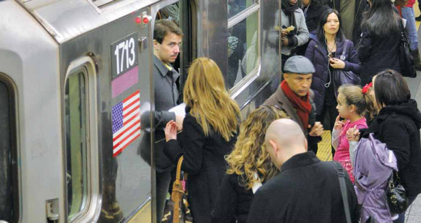
Commuters pack the 7 train at Grand Central Station, rush hour, Friday November 12. The extension of the 7 train to 34th Street and Eleventh Avenue–and maybe even to New Jersey–will be the biggest expansion of the subway system in years.
This summer there was a breakthrough–literally–in New York City’s efforts to upgrade its mass transit system. A 1,000-ton boring machine burst through a cavern wall below the Port Authority Bus Terminal to complete the 9,300 feet of tunnel in which an extended No. 7 train will run. The first major expansion of the subway system since the 1960s, the elongated 7 line will link new development in the Hudson Yards area to the rest of the city.
The 7-train extension is part of a massive project to build up the long-neglected West Side. Conceived back when the idea of building a stadium for the Jets drove West Side planning, the Hudson Yards project includes changes to the zoning code that could create 28 million square feet of office space, more than 12,000 residential units, and retail and hotel development. The Jacob Javits Center is also due for an expansion.
There is one odd thing about the 7-train expansion. The project began with two stations—one at 41st and Tenth and another at 34th and Eleventh—but is now down to one. So the city is spending $2 billion on a mile of track and a single station, and residential developers who were counting on the second station to make their projects viable are left in a lurch.
Packed platforms and crowded rush-hour rides aside, New York actually has an excellent mass transit system. “We’re the only system in the world that’s open for 24 hours,” says Gene Russianoff, the longtime transit advocate who serves as senior attorney at the Straphangers’ Campaign. Indeed, while other mass transit networks feature some round-the-clock service, New York’s full system operates ceaselessly. “We’re the only system in the world that has regularly scheduled express and local service. We’ve been express and local since 1904,” Russianoff adds. “There are few systems as extensive.”
The nonstop nature of the city’s system has helped New York create a 24-hour central business district—a significant cultural and economic advantage over cities like Dallas and Atlanta, where the downtown essentially closes at 7 p.m. And the subway system links to a web of commuter train lines that run to points as distant as Montauk, on Long Island; Waterbury, Conn.; and Bay Head, on the Jersey shore. “The thing that we have is the world biggest regional rail system,” says Regional Plan Association president Bob Yaro. “Other places are trying to replicate that. It’s an extraordinary asset.”
Yes, the MTA has been slow to adopt some new technologies—it’s only now installing screens that tell passengers on a platform when the next train is coming—but it deserves more credit than it gets. The MetroCard was a big move forward in the 1990s. In the past decade, the move to computer-based signaling has allowed dispatchers to know more precisely where trains are in a tunnel and, if the technology is working (it isn’t always), to run trains more closely together—one reason service on the L line, long one of the city’s worst, has improved recently.
And the 7-train extension is only one of several major capital projects under way to improve the system. After two false starts in past decades, the Second Avenue Subway is being built. A reconstructed Fulton Street transit hub will be completed in 2014. And the East Side Access project will give Long Island Rail Road passengers a chance to exit at Grand Central, linking the LIRR to the Metro North and five subway lines.
This transit system allows New Yorkers to live without the expense, hassle and environmental impact of a car. Some 4 million New Yorkers—42 percent of the city—live in households without access to an automobile. That’s equivalent to the entire state of Oregon not having a single auto. It makes for a far higher car-free rate here than in any other place in America. And according to Municipal Art Society president Vin Cipola, “Even the people who use cars here use them less: nine miles per day versus a 26-miles-per-day national average.”
Still, it’s an understatement that New York’s transit mix has its flaws. “Whole parts of the system are not up to a state of good repair,” says Russianoff, rattling off a list of needs from tunnel lights to station design to the control board he saw in one MTA tower that “looked like something out of Grand Hotel.” Not to mention that the system is, he says, “insanely crowded like all the time.”
Sam Schwartz, the former city transportation commissioner known as Gridlock Sam, says the problem is a lack of reliability: “Too many breakdowns, poor information, too many crippling service interruptions, especially on weekends, which are unfortunately necessary due to lack of basic maintenance over the decades.”
Many of the system’s problems are fiscal in nature: The MTA simply can’t afford to do it better. Others are structural: Like many—but not all—big cities, New York’s subway system radiates from the center out, the way it was laid out 100 years ago.
There’s logic to that orientation, given Manhattan’s traditional role as the city’s center of commerce, culture and government. But it has meant that getting from borough to borough is very difficult, retarding the development of independent downtowns in the boroughs. And it’s a poor fit for modern commuting patterns, in which a nurse might live in the Throgs Neck section of the Bronx but work at Elmhurst Hospital in Queens. The Staten Island ferry and the bus system tie the boroughs together but, Hunter College professor Tom Angotti says, “As every New Yorker knows, the bus system sucks.”
Other shortcomings reflect a web of circumstances. For decades there were calls for a one-seat train ride between the central business district and the city’s two airports. Mayor Rudy Giuliani proposed extending the N subway line to La Guardia Airport and building an AirTrain linking the subway system and LIRR to Kennedy Airport. Neighborhood opposition and budget constraints torpedoed the La Guardia line. The $1.9 billion JFK link was completed, but it’s far from a one-seat ride Giuliani sought. To get to the airport, you have to take the subway or the LIRR to the AirTrain, an hour-long prospect (compared with a comparable 30-minute ride in London). If you want a one-seat ride, you take a cab.
The obstacles to improving transportation in New York are well-known to the city’s transportation commissioner, Janette Sadik-Khan; one of her assistant commissioners jokes that “The only way to get across town is to be born there.”
But since her appointment in April 2007, she’s employed a range of policies to overcome—or at least drive around—some of those roadblocks. These include 250 new miles of bike lanes, pedestrian plazas in Times and Herald squares, and the closure of streets for Weekend Walks—a kind of street fair—and Summer Streets, when a route from Brooklyn Bridge, up Park Avenue and as far north as Central Park is closed off for a day to permit walking, running and biking. Jersey barriers—one of the grungier aspects of transport in the city—became canvasses for painters during “Hands On New York” day this past April. “Design is important if we want people to treat the city as a place and not just something to travel through,” Sadik-Khan told a Municipal Art Society conference in October.
There already practical benefits to what city DOT has done: Sadik-Khan says the increased foot traffic around the new pedestrian plazas has been a boon to businesses. And the midtown seating areas have brought injuries down 63 percent for motorists and 35 percent for pedestrians.
Under Sadik-Khan, the city is showing an openness to dramatic ideas. The administration is studying what would happen if it followed South Bronx environmental advocates’ advice to tear down the Sheridan Expressway, a relatively little-used 1¼-mile elevated highway that links the Bruckner Expressway to the Cross-Bronx— something the Bronx River Parkway does just 4,000 feet to the east.
But the changes with the biggest potential are on the city’s bus lines.
In an average year, New York City’s 4,561 buses carry 726 million people—more than the second-and third-biggest bus systems (Los Angeles and Chicago) combined. Buses are more flexible and far cheaper to build and operate than trains, but they’re notoriously slow. The Straphangers Campaign found last year that the city’s slowest bus, the M42, traveled at an average pace of 3.7 miles per hour. “A five-year-old on a motorized tricycle would outpace the M42,” the campaign cried. Buses move slowly because they have to fight traffic, stop at lights and—most time-consuming of all—wait at each stop for passengers to get on and pay their fare. In June 2008, the MTA and DOT began experimenting with bus rapid transit, a set of methods to reduce the delays that make bus service slow. The city and MTA introduced bus rapid transit—or, their preferred term, Select Bus Service or SBS—on the Bx12 line, which runs along Pelham Parkway and Fordham Road in the Bronx. They designated bus-only lanes on the roads, scheduled fewer stops along the route and started to give buses priority at traffic lights. But the biggest change has been having passengers pay at the bus stop and get a receipt rather than on the bus.
After a year, the Bx12 showed a 7 percent increase in ridership and a 20 percent decrease in running time. Transportation Alternatives executive director Paul Steely White says, “Fordham Road operates more like a train than a bus line” because of the new service. In October a second SBS line was launched, on the M15 bus line on the East side. The opening act was not flawless. “MTA debuts its Select Bus Service on a workday and … it’s just an ‘awful,’ ‘absurd’ mess,” screamed the Daily News. The Times made reference to “glitches and grumbles.”
Backers of SBS hope those are just growing pains. Bus rapid transit has caught on in Bogotá, Johannesburg, even L.A. It might be New York’s best hope for a better mass transit system. “Surface transit really is the only way we’re going to be able to grow our transit system on the scale that New Yorkers are used to,” says Transportation Alternatives deputy director Noah Budnick. “We’re not going to be adding more subway lines anytime soon.”
The MTA plans a third SBS route, on the B44 route along Nostrand and Rogers avenues in Brooklyn. That will open in 2012. Later that year, the most ambitious project to date—the 34th Street Transitway— will open in a busway, a lane that’s not just painted to be bus-only but barricaded by concrete to other cars; Sadik-Khan describes it as a kind of “surface subway.” The Obama administration is providing $18 million for the project.
But plans for a Hylan Boulevard SBS route in Staten Island have run into political opposition over the project’s impact on parking and car traffic. And a proposal for a Merrick Boulevard SBS route has been scrapped over the same complaints. So the M15 is an important test for SBS in New York.
Getting passengers used to paying before they board is only one challenge. SBS lanes can make it difficult for businesses on the bus-lane side of the street to get deliveries. Parking on that side of the street is also a no-no, so areas served by SBS have to surrender parking spaces. And SBS service requires prohibiting cars from an entire lane of traffic, which can carry 600 automobiles an hour. According to the RPA’s senior fellow for transportation, Jeff Zupan, there aren’t many streets in the city where there are enough bus trips during an hour to make a strong argument for cars to yield the lane.
“It don’t think it’s a panacea in every case,” he says of SBS. “There are selectively places where it works.” Indeed, as exciting as all today’s transit projects sound, a cold dose of reality is never far away. The Second Avenue subway is supposed to eventually run from the from Lower Manhattan to Harlem, but now there’s only funding for three stations on the East Side. And even those are unlikely to be finished on time.
“We’re putting about $2 billion into just sustaining a 100-year-old system, and that’s a very expensive hobby,” says Yaro. “The bad news is that the places that want to clean our clock are building brand-new transit systems.”
In 2007, as part of his PlaNYC proposal, Bloomberg proposed a new source of money for mass transit: tolling cars that entered or moved within the area south of 60th Street in Manhattan. It was political dynamite; PlaNYC’s authors didn’t know until three days before the report was printed whether congestion pricing would make it in or not. The plan certainly had its flaws—there were questions about equity for neighborhoods poorly served by transit, worries about the impact on small businesses, uncertainty about the ability of the city’s arterial highways to absorb the displaced crosstown traffic—and it had little if any grassroots support.
Still, it would have produced for the MTA some $420 million in annual revenue. What never came through in the 18 months of debate over congestion pricing was that its impetus wasn’t aesthetic or moral or even environmental, but purely practical. New York City’s survival depends on mass transit and the system is in a financial crisis that riders can’t fix: Transportation is the leading expense of low-income families—soaking up 30 percent of their pay. “It’s not just about the CO2 issue,” Rockefeller Foundation’s assistant director Edwin Torres says of the city’s transit challenge. “It’s about working people getting to work.”
It’s unclear if, beyond Bloomberg, New York’s political leadership understands the gravity of the crisis facing the nation’s largest transit system. During the debate over congestion pricing, Yaro met with one skeptical legislator and explained that 10 times as many people from his district commuted by subway as drove to work. His response was, “Don’t confuse me with the facts.” And during his campaign for governor, Andrew Cuomo said the MTA has to get by with the money it has. What money?
Even as the MTA struggles with chronic revenue shortages, it is being asked to transport a growing city—a New York that is 380,000 people larger than it was a decade ago, with nearly twice that number of people expected to arrive in the next two decades. But the MTA doesn’t decide where those people go. The New York City Department of City Planning does.
City Planning says it strives to encourage “transit-oriented development”—in other words, creating more room for development in areas well served by transit and reducing the room for new buildings in neighborhoods without good transit links. A recent study by the Furman Center for Real Estate and Urban Policy at NYU finds that the areas where the administration “upzoned,” or added residential capacity, tended to be well served by transit, with 74 percent of upzoned lots within a half-mile of a subway station. Of course, that means 26 percent of the upzonings—or 26 million square feet of potential new residential space—is not located near transit.
What’s more, Furman found that more than half the lots that were downzoned—or altered to allow smaller buildings—were near transit. So growth was blocked in areas that had the transit infrastructure to absorb more people.
And just because an area has a subway line doesn’t mean it’s actually “well served” enough to deal with new residents. It makes as little sense to site a massive new development next to a hopelessly overcrowded subway line as it does to put it where there are no subways at all. But the city’s planning process doesn’t always recognize the mismatch between land use plans and transit infrastructure. For instance, the environmental review for the 2007 rezoning of a swath of Jamaica, Queens, found that the move would most likely result in more than 5,000 new apartments and more than 1,300 new subway riders.
The subway lines at the Jamaica station were already 14 percent over capacity. But the review found no “significant adverse impact on subways” because the increase in passengers would average out to three new people per overcrowded subway car. Anything fewer than five new people per car, the city’s regulation for environmental review says, doesn’t count.
A different problem could arise along the path of the new 7 train. The project began with two stations—one at 41st and Tenth and another at 34th and Eleventh— but is now down to one. “The argument the city made when they dropped it, aside from the fact that they didn’t have enough money for it, was, ‘Development has happened on West 40th without it, so we don’t want the station,’ ” says the RPA’s Zupan. “Now you put people in places where they expected to have a station, and now they’re stuck without a subway.”
The planning problem starts in the transit system. “There is no central place that plans for transportation in the tristate region,” Schwartz says. “The MTA, NYC DOT, NYS DOT, Port [Authority], NJ Transit, NJ DOT and Connecticut DOT each do their own planning, which is very dependent on leadership and politics.” But it is complicated by the absence of any formal connection between the people who plan where New Yorkers live and work (City Planning) and those who run the transit systems.
There is also a dangerous dissonance between what the administration sees as progress and what communities detect. This goes beyond the NIMBYish opposition to bike lanes. At the October MAS conference, Sadik- Khan pointed to a marketing brochure for a snazzy new residence in Brooklyn. She was pleased that one of her bike lines was featured as part of the appeal. But the building in question, New Domino, is where the city, contrary to community wishes, changed zoning rules to allow a developer to build a massive new complex, bringing more people to an area of Brooklyn where transit and schools are already strained.
The bike lane looked cool. But there was something wrong with the rest of the picture.


