Share This Article
To really get New York City, you can view its enormity through an airplane window, or sense a neighborhood’s spirit on a walk up and down its streets. Or you can stand, hands on knees, looking at a single patch of ground. You can measure how much of it is covered by green, note which species of plants are visible and gauge how much sunlight is pouring through the tree branches above.
One recent afternoon in a corner of Pelham Bay Park, Silvia Bibbo crouched down to get an even better look at a piece of the Bronx that most park-goers wouldn’t glance at twice. “See this? This is from a deer,” she said, pointing to the thin wisp of stem that remained from a plant. Sifting a clump of soil through her fingers, she picked out tiny balls of dirt. “Earthworms leave these,” she noted.
Bibbo was one of a team of three scientists from the Natural Areas Conservancy (NAC) engaged in a groundbreaking, two-year biodiversity survey of the 10,000 acres of New York City’s sprawling park system that are forests, marshes, grasslands and wetlands.
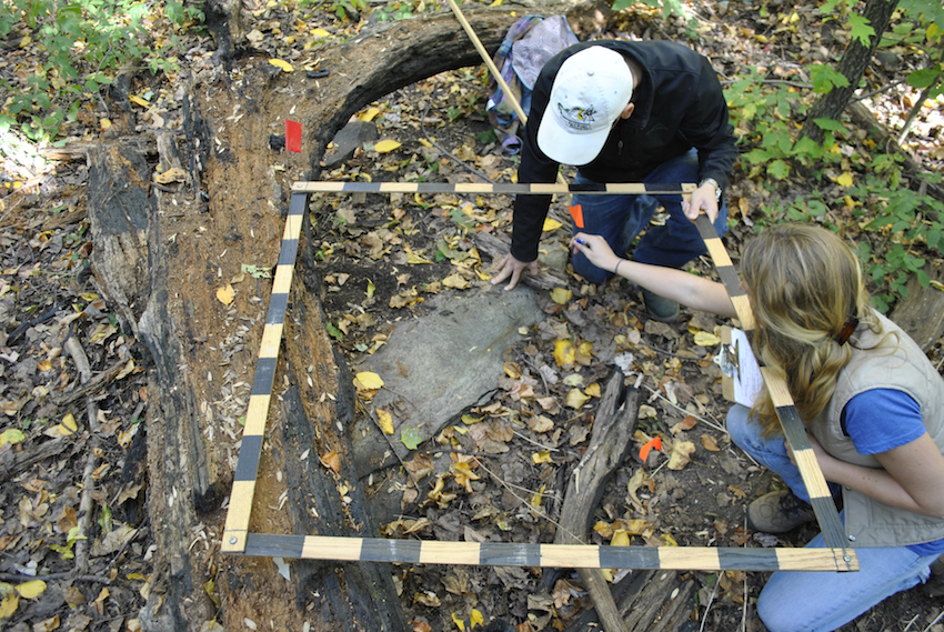
Earlier that day in Pelham Bay, clad in rubber boots and lugging a laptop and a tape-measure, Bibbo and her teammates found that randomly chosen spot wedged between a hiking trail and a lonely inlet, mapped out a 10-meter-by-10-meter square, and began looking at everything in it from the soil to the point where treetops give way to sky. Looking on, NAC vice president Sarah Charlop-Powers said the impetus for the massive survey was simple: “We need a better understanding of the ecology, of what is here and what is healthy.”
NAC’s project is not the only ambitious research project underway in the city’s green spaces. The U.S. Forest Service is also in the second year of a huge social assessment of parks, aimed at documenting the different uses that different people, at various times of the day, make of parks in all five boroughs.
When the data from the nature survey and the social research assessment are made public and analyzed together, they should give policymakers a tool for making wiser decisions about resource allocation—intelligence for better managing the park system on a site-by-site basis.
Already, however, the projects have sketched out the stakes involved in protecting New York’s open space. “[The assessment] tells the story of natural areas and why they have value, even if they’re not seeing the kind of numbers that Sheep Meadow in Central Park does,” says Lindsay Campbell, the social scientist in charge of the Forest Service survey. “How do you measure the value of a place someone has been coming to for 30 years?”
One city, two coastal ecosystems
The Natural Areas Conservancy was established in 2012—set up, like other conservancies around the city, as a way to devote non-government resources to protecting parks. Unlike most other conservancies, however, it was attached not to a particular park but rather to a type of parkland spread throughout the city.
Thinking of a New York City park, one usually pictures trees in Central Park framed by skyscrapers or hears the squeak of a playground swing. But many of the wetlands and beaches off Jamaica Bay are also part of the park system, as is the Twin Islands trail off Orchard Beach, which winds through marshland to reveal a rocky headland that looks closer to Maine than Manhattan.
Beyond their natural beauty, the city’s wild areas are scientifically significant because they straddle a border between two different coastal ecosystems: Staten Island lies at the northern end of the mid-Atlantic, while the Bronx sits on the southern side of the New England coastal region.
Because these areas are more remote and more challenging to care for, support for them historically has moved in a boom and bust cycle, says Charlop-Powers. NAC was launched to create a more consistent funnel of resources. One of its projects is growing beach grass to help solidify coastlines torn up by superstorm Sandy.

But the biodiversity survey is the flagship project. Operating for six months last year and six months in 2014, it involves surveying 1,500 sites across the five boroughs. This year, the work was carried out by five forest research teams and two other teams focusing on marshes and wetlands. Each unit was assigned GIS coordinates for the sites they were responsible for visiting. Sometimes the sites were easy to reach; other times, says Brian Tarpinian, a forest researcher on Bibbo’s crew, “We had to hack our way through to them.” Once there, the teams measured out a 10-meter-by-10-meter box around the location point and began to look around, entering detailed data through a specially designed program on a laptop.
The data included the state of the herbaceous layer—what laypeople call “ferns”—the presence of litter and the amount of fallen trigs and branches, which will become nutrition for the next generation of trees. Trees themselves were rated on a scale of one to five, with 1 being a very healthy tree and 5 being a dead one, the number taking into account everything from the trunk diameter to the amount of “die-back”—how far toward the trunk one sees leafless zones on a tree’s outer limbs. A photo was taken looking straight up along the tree trunk to document just what the forest ceiling looks like at that point. Soil samples were drawn. “We can compare the data set with the entire East Coast,” says Kim Thompson, the third scientist on the squad.
Then the team focuses on a smaller sub-plot, one meter by one meter, where they look even more closely at leaves, branches, even the texture of the dirt. All the evidence tells a story about that spot of the city’s wilderness. A grid can take an hour to document, or it can take all day.
The survey has taken teams to 20 parks, including Pelham Bay Park, Van Cortlandt Park, Riverdale Park, Bronx Forest Park, Seton Falls, and Givans Creek Park in the Bronx. Charlop-Powers has been surprised at the amount of diversity, with some 2,000 species of native plants being found. For all the stress that some wild areas are under, she says, there are also “a lot of intact and healthy places.”
For Tarpinian, the takeaway so far is that those successes are not accidental. “There’s this idea people have that if you just leave a forest alone, it will be fine. That’s based on assumptions about how systems are working in an urban environment. There are not many facts.” The presence of invasive species is one indication of a management need in the city’s wild spaces; Tarpinian says invasive plants have been seen in every plot and sub-plot his team has visited.
A social dimension
Unlike Forest Service outposts elsewhere, the New York office doesn’t directly supervise any federal forest land. Instead, it exists to study and support the link between people and natural areas. The service’s social assessment, called Reading the Landscape, is part of that mission. It began in 2013 with a survey of areas around Jamaica Bay and continued this year with a focus on other parks throughout the five boroughs.
“We wanted to take stock citywide of the health, quality and use of the areas,” says Campbell, who along with fellow Forest Service research social scientist Erika Svendsen has headed up the survey. “While they’re trying to understand the bio-physical quality of open space in the city,” she says of NAC’s project, “we’re trying to understand how parks are used, valued and what is the social meaning of these spaces.”
The assessment, which has involved more than 20 researchers at one time or another, visited 17 parks last year and 22 this past summer. Each park is visited three times—once during a weekday, once on a weekend day, and once in the evening. The researchers do what’s called a rapid survey, sweeping through parks conducting interviews (“Why are you in the park today? How did you get here?”), observing behavior and looking for signs of use like unofficial paths, graffiti and evidence of homeless encampments.
All told, the survey collected 618 interviews in the summer of 2013 and more than 1,000 this past summer, with collection ending just last week. The staff are now crunching data to produce a white paper and individual park profiles later this fall. A journal article based on the 2013 findings is being reviewed for publication next year. Eventually, all the information will be made public.
The answers so far have only raised more questions: Campbell thinks future social surveys might dig even deeper to look at what happens in parks overnight, or during the winter, and look deeper into the different ways people use parks, like interpreting just what all the graffiti means.
The biophysical survey is also getting closer to its data release; surveys will stop on October 10 with a goal of distributing information next year.
The breadth of the NAC survey makes it a first, says Charlop-Powers. “We do have some historical data. But it used to be done park by park. We missed how species moved between parks,” she notes. NAC’s research should capture more of that system-wide dynamic. The researchers hope it becomes a benchmark.
The larger hope behind both studies is that they’ll help the city figure out how to most effectively use its limited resources to support the role that wild places play in New Yorkers lives. The biophysical data may even permit scientists to create handy metrics for deciding whether an area of parkland, simply put, is healthy or not.
Some of the results, of course, will defy easy quantification. “The basic finding is that these parks are really crucial,” Campbell says. Time and again, the social researchers ran into people who identified their parks as places of refuge—a natural buffer against a dense and noisy city—but also sites for socialization, and critical elements in a neighborhood’s resiliency. And a word that came up often, Campbell says, was “sacred.”
The spiritual dimension was easy to see, she adds: “We often find it in the language people use or the signage that they leave.” It’s in flowers and coconuts that indicated a Jamaica Bay beach was used to Hindu ritual offerings. Or people talking about using the parks for “centering”—becoming, for just a moment or two, part of the thing that connects soil to sky.