
DCP
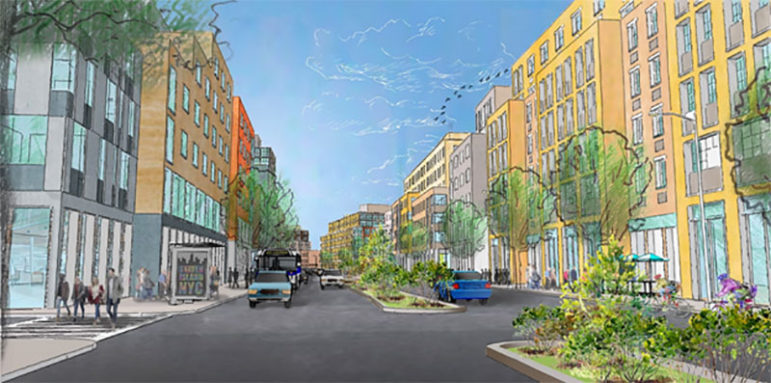
A rendering of the city’s vision for the Bay Street corridor.
After a three-year wait, a much-anticipated Staten Island rezoning proposal was certified by the City Planning Commission on Tuesday to move into the public-review process for the land-use portion of the plan that focuses on the Bay Street corridor stretching from the Tompkinsville to Shore Acres neighborhoods.
“Imagine the Bay Street Corridor that stretches from St. George to Stapleton as a walkable, vibrant live-work-play community that supports jobs and, for the first time, housing, including affordable housing,” City Planning Commission Chair Marisa Lago said. “As we begin the public review of the Bay Street Corridor Neighborhood Plan, we want to hear from Staten Islanders about their vision for an even better North Shore for themselves, their children and grandchildren.”
Along with triggering ULURP or uniform land use review process—the City Planning Commission also released the draft environmental impact study on the Bay Corridor neighborhood plan. The Staten Island rezoning proposal is part of the de Blasio administration’s housing plan, which aims to create 300,000 affordable housing units across the city, partly through the rezoning of at least a dozen neighborhoods across the five boroughs.
“After nearly three years of community input, the Department of City Planning is releasing its draft Environmental Impact Statement, beginning a seven-month period of public review culminating in a vote at the City Council. My position with the administration over the last three years has been clear: We will not undertake this rezoning without public investments in appropriate infrastructure to support a future increase in density,” said Councilwoman Debi Rose, whose district includes the targeted area. “The right mix of market-rate and affordable housing will provide space for seniors, families, young professionals and more, preserving the culture, fabric and opportunity of our North Shore neighborhoods. This blueprint would respect waterfront view corridors and enhance public access to our waterfront.”
The proposal
The Staten Island rezoning proposal includes the St George, Tompkinsville and Stapleton neighborhoods, an estimated 14-block area along Bay Street bounded by Victory Boulevard to the north and Sands Street to the south, including the two-block area along Canal Street south of Bay Street. It is slated to create an estimated 1,800 mixed-income apartments.
The proposal includes the development of two city-owned properties; 55 Stuyvesant Place and 539 Jersey Street for job creation and mixed-use (commercial and residential) development with affordable housing. Two special districts, the Special Stapleton Waterfront District and Special St. George District, will be expanded and remain for commercial, residential and retail use.
The proposal calls for rezoning along the Bay Street and Canal Street corridors, which have not seen any zoning changes since 1961. The Bay Street Corridor is currently a light manufacturing district and the R3X district west of Bay Street is a lower-density residential district for one and two-family detached homes. The city wants to amend the zoning there to R6B, which applies to traditional row-house districts, and will fall under the Mandatory Inclusionary Housing (MIH) program requiring the creation of income-targeted units.
Along the Canal Street Corridor, blocks surrounding Beach Street and Canal Street are currently zoned R3-2 and R4 districts, allowing for low-rise, multifamily apartment houses and detached and semi-detached one- and two-family residences. The city proposes to change the zoning to R6B for medium-density residential use*.
One of the major concerns of community groups such as the Staten Island Housing Dignity Coalition was whether deeply affordable housing units would be part of the proposal. It remains unclear which of the MIH options, which offer different levels of affordability, will apply.
The Department of Housing Preservation Development will provide to the rezoning area tenant protection programs including the Certificate of No Harassment program and the Neighborhood Pillars program to preserve existing affordable housing and legal assistance to North Shore tenants who face eviction or harassment.
“Developed through extensive community engagement, the Bay Street Corridor Neighborhood Plan is focused on creating opportunities for good jobs, space to support new and existing businesses, and affordable homes that will anchor this dynamic community. We look forward to working together with our partners in the community to solidify and advance a comprehensive, coordinated approach to neighborhood investments that will serve Staten Islanders for generations to come,” HPD Commissioner Maria Torres-Springer said.
Existing commercial zoning C2-3 and C2-4 will remain over portions of the proposed R6B and R6 zoning districts. C2-3 and C2-4 commercial overlays are for typical retail uses such as neighborhood grocery stores, restaurants and beauty parlors. C2 districts permit a slightly wider range of uses, such as funeral homes and repair services.
The city is also pointing to streetscape improvements, new school capacity and new open space as part of its larger plan for the area.
The impact
According to the DEIS, the rezoning will lead to an increase in housing by 2,557 dwelling units and would likely increase the population by 6,571 new residents. The study says a little over a dozen residents are expected to be directly displaced. The city’s methodology for predicting displacement has been sharply criticized.
However, the study also revealed that an estimated 1,753 residents in unregulated housing units are at risk of being indirectly displaced by the proposed actions*. In order to mitigate the displacement, the DEIS says, “In line with the city’s MIH policy, an estimated 25 to 30 percent of new housing units would be made permanently affordable within the Study Area. The impact of additional unregulated housing resulting from the Proposed Actions would be eased by the provision of affordable housing for a preexisting population vulnerable to indirect residential displacement.” The DEIS notes that some displacement risk would exist even without the zoning because of existing real-estate trends.
The study says the population increase would require another analysis to accommodate a new student population of approximately 1,125 total students, including approximately 537 elementary school students, 230 intermediate school students, and 358 high school students but the study concluded that “the Proposed Actions are not anticipated to result in a significant adverse impact to public schools.” If the impact is significant then the study proposes to restructure existing schools or adding new space to create more capacity.
The study also expects that there is potential for directly displacing 30 businesses representing retail, grocery, car repair, banking, and other services. Approximately 244 employees at these 30 businesses are likely to be displaced, representing approximately five percent of employees in the study area and approximately 0.26 percent of employees in Staten Island. These 30 businesses include a gas station, Western Beef supermarket on Bay Street, a pharmacy, a deli, a cell phone store, a clothing store, beauty supplies store, an automotive parts dealer, and five motor vehicle dealers, according to the study.
According to the DEIS, the Special Stapleton Waterfront District and Special St. George District, will be for commercial, residential and retail use. The proposed zoning text amendment would alter the maximum building height on Stapleton Waterfront from 55 feet to 125 feet in order to enhance waterfront views. It includes altering traffic patterns to accommodate safety for pedestrians and cyclists and parking space.
The rezoning proposal also includes improvements to existing parks and public school playgrounds accessible to the community after school hours including the possibility of a new recreation center at the Lyons Pool site. Development for additional open spaces may be determined later in the public review process.
The study emphasized that there would be significant adverse traffic and transit impacts within the bounds of the study area. It listed dozens of intersections that could be affected by the rezoning. For transit, the rezoning would generate a net increment of approximately 433 and 578 new Staten Island Railway trips during peak commuting hours during the week. The study area also is served by 22 MTA bus routes and the rezoning would generate approximately 860 and 1,093 incremental bus trips during peak hours. The plan to mitigate the impact on bus transit would mean adding two to six additional standard buses to each direction of each route during both peak hours.
The concept for the Bay Street Corridor district came from the North Shore 2030 Report, released in 2011. According to the Department of City Planning, the proposal was refined through “constant engagement” between city agencies and a Bay Street Corridor Plan Local Advisory Committee (LAC) which included area stakeholders, including representatives of Councilmember Rose, Borough President James Oddo, Community Board 1 members, religious leaders, civic representatives, business representatives and community organizations.
But the Staten Island Housing Dignity Coalition said despite three years of sessions with city agencies, the environmental impact statement still raises some of the same old concerns: public land, MIH, tenant protection and local jobs.
“Quite frankly, I am quite disappointed. It appeared to me that the three years we have been talking to people and they have listening intently but we don’t see anything on paper,” said Deacon Mary Bourne-First, from Central Baptist Church and a member of the Staten Island Housing Dignity Coalition.
According to the Staten Island Housing Dignity Coalition, only one of the three city-owned properties would be used for affordable housing and it was listed as 50 percent. The coalition called the number of residents subject to potential displacement “worrisome.” On local jobs, the coalitions says it had been pushing for at least 50 percent of the jobs to be reserved for residents but the city has not committed to that.
“We feel very strongly about public land being used for public good. The public land is a prime opportunity for the city to build affordable housing for what the community needs. I know families – generations—living under one apartment. These people work everyday and contribute to the community,” said Deacon Mary Bourne-First.
The coalition said they have reached out to Rose who has agreed to meet with its’ members and are waiting to hear back from city agencies. The community organization is prepared to what it says is the “six-month fight” with the city to meet its demands. According to Rose’s office, the Councilwoman is not in favor of the option that targets the 115 percent AMI also known as the Workforce Option which the coalition also opposes as an MIH option for the North Shore community.
“Nothing reflects the discussions we have had. These communities are already rent burdened and are likely to face more trauma. It places families in jeopardy of homelessness. This is what we fear as Christian leaders—these statistics do not truly reflect the income levels of the North Shore,” said Reverend Janet Jones, pastor of Rossville AME Zion Church and member of the Staten Island Housing Dignity Coalition. “We want 100 percent affordability on public land; the public should have the right to say what goes on public land. They keep using this term affordable but our question is affordable for whom?”
The launch of the seven-month public review process starts the clock. The Staten Island Community Board 1 has 60 days to review the proposal then it is passed onto the after Borough President and then comes back to the City Planning Commission and ultimately to the City Council as part of the city’s Uniform Land Use Review Procedure (ULURP). For further information on the zoning proposal or the ULURP time table, please visit the Department of City Planning website.
*Corrections: The initial version of this story erroneously reported that the DEIS says 1,700 low-income residents would be displaced. The DEIS, however, only says that number could be displaced. The DEIS also notes that existing trends would create a displacement risk even if the rezoning didn’t occur. It also erroneously reported that R6B zoning includes buildings up to 13 stories; in fact, R6B zoning has a 55-foot height limit, but R6 zoning—which is also part of the rezoning—could reach 13 stories.
City Limits is a nonprofit.
Support from readers like you allows us to report more.


3 thoughts on “Staten Island Rezoning Begins Public Review; 1700 at Risk of Displacement”
If they raze the Western Beef, where will residents get groceries? Will they build a “Whole Paycheck” to replace it?
If this plan goes through maybe Western Beef or some other supermarket will occupy one of the larger retail spaces. But you can forget about a Stop-N-Shop or ShopRite ever opening up there.
There is no way that SI can add 6600 people without straining the island’s old limited infrastructure. The DEIS is just more deBlasio propaganda.