
Mayor's Office of Resiliency
When it comes to shoring up defenses against rising water and stronger storms, there are currently three separate plans encompassing four distinct areas of lower Manhattan.
Stand along the East River waterfront in the Financial District, and it quickly becomes how big a task City Hall has set for itself in protecting lower Manhattan from sea level rise. Manhattan’s southern tip is ringed by low-lying land — appropriate for an island that was significantly expanded in its early days by landfill on “water lots”— and its shoreline is a motley assemblage ofpiers, highway stanchions, and Department of Sanitation and Con Ed facilities that reflect the river’s history as a working waterfront and present as an attraction for tourists and locals alike.
In recent weeks, amid the vastness of the lower Manhattan waterfront, a tiny speck of a folding table has appeared on Fridays along the river, staffed by a few city officials seeking to explain City Hall’s multi-billion-dollar plans to create a complex network of flip-up flood gates, earthen berms, and other mechanisms to prevent a repeat of the catastrophic flooding that accompanied Superstorm Sandy in 2012. Following reaction to the $10 billion price tag attached to Mayor Bill de Blasio’s announcement last March of plans to add more than 50 acres of new land in the East River around South Street Seaport, as well as continuing uproar over the city’s plans to bulldoze and rebuildEast River Park, city officials are taking pains to stress that they’re aiming for a bespoke plan that will stave off future storm surges without unnecessarily inconveniencing New Yorkers.
“Community engagement is extremely critical to all of the projects,” says Jainey Bavishi, director of the city’s Office of Recovery and Resiliency. “We’re hosting public meetings on a regular basis, and are happy to meet with whoever is interested on any of these projects to make sure that they’re informed about the status and extent.”
But while construction on the first phase of the project, the southern section of Battery Park City, is expected to begin by the end of next year, the most difficult and contentious section — the nearly mile-long stretch between Brooklyn Bridge and Battery Park — remains up in the air in terms of planning, timeline, and funding, with a master plan only first set to be released in 2021. What the ultimate flood protection measures there will look like, and how much they’ll cost and who’ll pay for them, likely won’t be resolved until there’s a new administration in the White House, and likely City Hall as well.
New York City’s sea level has already risen nine inches since 1950, and is expected to jump by as much as six feet more by the end of this century, as part of the worldwide climate crisis that is threatening to engulf coastal cities across the globe. In addition, the city projects that storm surges from climate-change-fueled storms could add as much as 16 feet of water on top of that—an onslaught of sea water that combined would dwarf the 14 feet of surge that flooded much of the city during Sandy.
These are, of course, only guesses, as no one can say for sure how much the sea level will rise in coming decades, and no one knows when or how often big storms will hit, or how big they’ll be.
“If we’re looking at the science of this, risk increases every year — every year your chances of another storm increase,” says City Tech architecture professor Illya Azaroff, who has consulted with New York and other cities on climate resiliency plans. And with flood-proofing efforts already years in the works and years away from having funding identified, let alone construction completed, he worries that the city could be left with holes in its defenses: “If you can’t get all the puzzle pieces together, do you subvert your overall planning effort in the long run? You’re only as strong as your weakest link.”
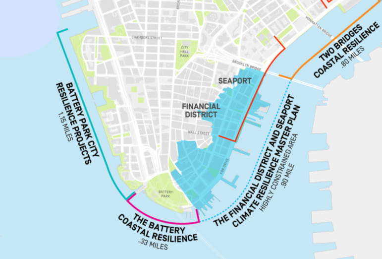
Keeping from being entirely undermined by your weakest link is one reason why the Lower Manhattan Coastal Resiliency project has been split into at least four projects, designed to operate as separate modular pieces. Whereas three years ago the city and the federal Department of Housing and Urban Developmentapproved a proposal for what was termed the “Big U“—a single set of flood barriers to wrap around the island’s entire tip below Canal Street—current plans more resemble a set of brackets: The East River Park section has been split off into its own separate project, while the LMCR has been divided up into four segments — Brooklyn Bridge to Montgomery Street, the Seaport, Battery Park, and Battery Park City — each of which will proceed on its own timetable. (And, crucially, its own budget, meaning some sections can be started on while others are still awaiting funding.) And each will operate independently as well, with floodwalls tying back to high ground at their end points; so if a storm strikes after the Two Bridges section of the wall is complete but before the Seaport is, water won’t be able to back up into low-lying areas and flood adjacent sections.
The first piece scheduled for completion is also the simplest. From Montgomery Street down to Brooklyn Bridge, a set of flip-up flood gates will be put in place to allow city workers to quickly wall off the neighborhood if a storm threatens. (In a few sections where there’s already no access to waterfront, permanent rolling gates will be installed instead.) This has already received $203 million in city capital funding and federal disaster recovery funds, and is set to begin construction before de Blasio leaves office in January 2022.
The Hudson River side of the U is slated to be far more complex. Battery Park is currently set to receive two different flood-control elements: a rebuilt wharf along the river’s edge that would raise the waterfront promenade by several feet to stave off day-to-day flooding. (Today’s steps down to the promenade would turn into steps up, notes Hutchinson, which is intended to “preserve views and the character of the park.”) To protect from storm surge, a raised bike path will be built in the inland part of the park, allowing most of the park to remain closer to river level, since a park can survive storm-surge flooding mostly unscathed. The bike path would connect to Battery Park City to the north. Battery Park City, which was already built at somewhat higher elevation atop soil excavated for the construction of the World Trade Center, would be targeted by a smorgasbord of approaches, including higher seawalls, raised park spaces (City Hall says it doesn’t know yet how much parkland will have to be closed as a result or for how long), and removable flood barriers. The total price tag of$267 million has already been allocated from a combination of city capital dollars (for the wharf) and Battery Park City Authority revenues (for the berm and other elements).
Which leaves only the most troublesome part of the project: the Seaport, the stretch running from Brooklyn Bridge to the Staten Island ferry terminal where de Blasio proposed his $10 billion landfill plan last spring.

City officials say the Seaport section is especially problematic for multiple reasons. Because the area is exceptionally low-lying — much of it was itself built on landfill, which explains why Water Street now sits two blocks inland — buildings are virtually at sea level, which would make any flood control structures exceptionally obtrusive. In addition, the elevated FDR Drive dips lower south of the Brooklyn Bridge en route to its tunnel beneath the Battery, leaving little room for the 15-foot-high flip gates the city plans to build into the pavement further north.
And there are subterranean obstacles to simpler solutions as well.”Sometimes you are drilling the foundations of these gates 50 to 70 feet underground,” says EDC vice-president Elijah Hutchinson. “So things like subway tunnels or the FDR going subsurface or the Battery Tunnel start to really matter.”
In the short term, the city is readying four-foot-highsand-filled barricades and water-filled Tiger Dams that should protect against surge from the type of storm New York City is expected to experience every 15 years or so. For Sandy-type storms, the only protection will come from whatever long-term methods the city arrives at in its 2021 master plan.
The city’s longer-term solution remains dumping landfill into the East River, though officials are quick to assure questioners that this could mean as much as 500 feet of new land, or as little as 50. This would likely be topped by some kind of berm, to avoid underground complications; while a berm could be built on the current shore, the limited space available would mean an abrupt wall of earth, whereas on new land it could take the shape of a gentler slope up to a raised waterfront.
The ultimate cost of the project is unknown, but will almost certainly require federal aid — as would other even more extensive flood protection measures, such as the $120 billion network of tidal gates and floodwalls proposed by the U.S. Army Corps of Engineers in February. And that will depend on what the Washington landscape looks like following the 2020 elections: While climate resiliency infrastructure would presumably be part of any Green New Deal legislation, it’s not likely to go anywhere without a Democratic Senate and White House.(Neither House nor Senate Democratic leaders on climate committees returned City Limits queries for this article.)
The uncertainty means that even as City Hall insists that it is devoted to seeking public input, it can’t say exactly what that process will look like; the Seaport work could be forced to go through the Uniform Land Use Review Process or not, depending on what the work actually entails.”It’s so contingent, particularly on how the phasing of this works out,” says Hutchinson. “Without even knowing that, it’s hard to tell what the triggers would be for a land use review process.”
That’s bound to get local residents on edge, especially after a public planning process for the city’s sea-level resiliency plans immediately to the north ended in rancor and possible lawsuits. “In East River Park there was a whole four-year process where Rebuild By Design and the community spent years working on a park plan that was scrapped last year,” says Pat Arnow of East River Park Action. “They started pleading with us, ‘Oh, we’re listening to the community, we’re listening to our stakeholders.’ But they haven’t done any meaningful revisions based on community input. It’s a show.”
At the same time, Azaroff wonders if building higher walls is necessarily the best use of city resources. The typhoons that recently struck Japan, he notes, were exceptionally destructive because unexpectedly strong storms overtopped berms and levees, catching unawares residents who had chosen not to evacuate because they assumed they were safe: “They lost a lot of lives, because people had thought, hey, we’ve been behind these protection measures for a while now. And the severity of this storm defeated that.”
Azaroff would rather see New York City spend its money on a more comprehensive systems approach that addresses not just holding back the water but figuring out how to live with it — and not only in the high-priced Manhattan district where New Yorkers work, but in the lesser-valued boroughs where they live as well. Hamburg, for example, is rebuilding its HafenCity district on raised platforms 26 feet high, on the premise that no flood walls can prepare for every eventuality.
“In Shanghai, they’re looking at sponge cities 100 percent,” Azaroff says, replacing pavement with wetlands and creating “rain gardens” to retain water during flooding. “What we’ve known how to do for thousands of years is to build a higher wall. And we’ve known for thousands of years that Mother Nature says: ‘Now you need to build it higher.'”


0 thoughts on “Seaport Section Remains Big Question Mark in NYC’s Flood Control Plans”
Pingback: Commercial Rent Control Returns; Real Estate Cool On Trump - Uber Homes | Connecticut Real Estate Property Listings
Pingback: Pol aims to cap commercial rents, Real estate pros cool on Trump | ReallyList.com
Pingback: Pol aims to cap commercial rents, Real estate pros cool on Trump | Juspost NewsHub